


The road to Muggleton: a pictorial introduction to the Amesbury incident
The British Government says that late on Saturday, 30th June, a man was extracted from a flat on Muggleton Road, Amesbury, suffering from the same kind of poisoning that the Skripals had previously, famously, suffered in nearby Salisbury. Earlier in the day, a woman was also taken from the same address and later found to be distressed for the exact same reasons. However, no news of this event was released until a number of days had passed, and then details principally seemed to come from a television interview with a supposed friend of the couple. As always seems to be the case these days with friends and family of victims in such incidents, this character was able to hold his own in front of a camera, with a slight twinkle in the eye and a smile playing about the lips. And so, of course, the invitation to be suspicious had duly been issued. But going to any great length to understand that this character should not be trusted, or to discover that the narrative does not hold water is for another time (although even a brief perusal shows that this latest offering from Government has started with the usual fragmented storyline). Indeed, enough has probably already been written here at FBEL about this incident for the time being. In this article, we are mostly going to look at pictures.
Although the flat of Charlie Rowley (and Dawn Sturgess?) is on “the Muggleton road” – Muggleton Road does not in fact lead to Muggleton. It appears to be a tiny stretch of lane between two portions of Princess Way, according to Google Maps. The dwellings on this lane also appear to be entirely brand new; in fact, Zoopla, as of 11am on July 5th 2018, has no sales history for any of the odd numbered flats on Muggleton Road between 1 and 11. (And Number 9 appears to be valued at around £300,000 – the reader will see the significance of all these numbers in a moment). That doesn’t mean that the flats aren’t being lived in of course [although it would be interesting to discover if any are not]; the point of the exercise is to use the information to understand as best we can, without being in possession of the actual build dates, the very recentness of the development that constitutes Muggleton Road and the dwellings that stand upon it.
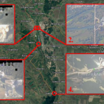
Consider the image below, taken from Google Maps.
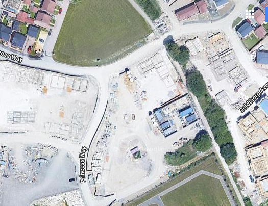
Princess Way, as can be seen, enters from the south, and bends round to the west, but it also splits off into what is now Muggleton Road – which then rejoins another portion of Princess Way to the east (according to Google Maps [see image at foot of page]). Obviously, what should strike the viewer of this image immediately is that they are looking at a building site. The bit we are interested in is the central area between Princess Way and the line of trees. This is where the flat at the centre of this story is to be built.
By looking at the street view in Google, we can tell that the development took place after June 2017 because that is the date of the most recent imagery, and in that imagery the scene is still one of a vast building site. Indeed, the data is not available for most of the landscape shown in the above image – the closest a camera car got to our area of interest was the top right hand corner.
We know that we are looking at the correct location in Google Map, despite the empty spaces, because of comparisons to be made with an overhead shot of the “scene of the crime” released by Sky News – below.
The Sky News overhead is shot from the north. At the back is the field that appears in the bottom of the Google Map image. At the front is the triangle of grass, and then the line of trees are aligned north-south, crossing the lane and overhanging a pathway. Also at the back of the Sky News overhead is the larger tree that is offset from the line on the other side of the path, with two much smaller examples then further west. On the Google Map image, these trees are on the patch of dark land neighbouring the southern field. One can also see the T-junction in both images, as well as the access road that bends round from the west to the south in the housing estate itself. Please notice the lie of the shadows in the Sky overhead image. They fall towards the viewer, and in front of the nearest line of houses – meaning the viewer is positioned to the north. The Google Map corresponds – shadows are being cast towards the top of the image (therefore projecting north); the best example is from the solitary tree near the southern field.
Now consider a shot of Muggleton Road from the ground.

This image was released by some corporate-media or other, and discovered by an image internet search. The viewer is roughly looking west to east into the courtyard of the complex where the flat in question is located. Notice the line of trees, and also notice the position of the T-junction. The viewer might care to notice at the end of the building with the white plank facing, there is a woman leaning on the place name sign which, we presume, reads “Muggleton Road”. We see enough lettering to suggest that it does indeed read as guessed. Speaking of which, it’s anyone’s guess what the fellow with the woman at the sign is doing – however, they both seem to be having a good time.
The next image was also obtained by searching the internet.
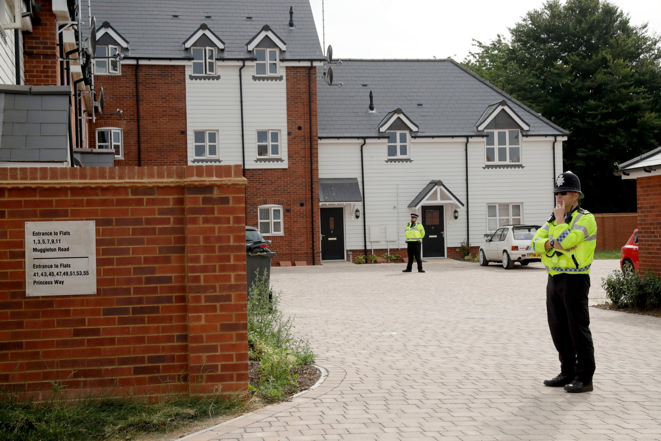
It affords a closer view of the courtyard, but of special interest is the sign on the wall that says “Entrance to Flats 1,3,5,7,9,11 Muggleton Road”. Zooming in on the image allows the viewer to see that the white plank faced dwellings to the right are numbered 9 and 11. Notice the porticos over the doors on these houses. Number 9’s is a lean-to style, while number 11’s is more of a temple-front affair. Notice the white car (a Peugeot) that appears to be outside Number 11. These houses are aligned north to south, and if the reader would care to notice, the police in view are casting shadows that fall to the viewer’s left, indicating that southwards is to the right and the back of the image.
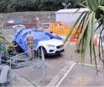
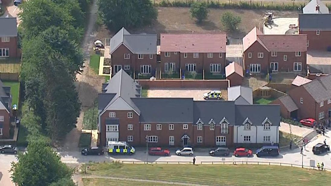
The final image to examine is from a film obtained by Sky News purporting to show Charlie Rowley on a gurney being put in an ambulance (the line across it is due to having to capture the image with two screenshots that were joined together in Gimp). Please notice that the incident appears to be taking place immediately outside Flat 9, although we have no evidence that tells us exactly where he fell ill, and the viewpoint is from north to south.
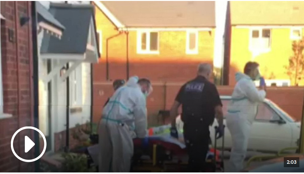
It must be late in the day because the sun appears to be casting a shadow on the buildings at the back of the scene. The only way this could happen is if the sun was northwards in the western sky and close to setting. Indeed, we are told that his incident took place between 7pm and 10pm – neighbours were instructed to stay in their houses between those hours (naturally, that way one can’t get a good idea about what is going on). Given that sunset, and the start of dusk, was at 9.20pm, and that there is still plenty of light in the sky in the image (as seen between the house, and reflected off the cars), then this must be, at a best guess, between 7.30pm and 8.30pm because this is when the sun, due to the alignment of the complex, was probably shining straight up along the course of the entrance into the courtyard and casting a low shadow from where it struck the house on the left of the drive.
So, all appearances suggest that emergency services turned up at Muggleton Road on Saturday, between 7pm and 10pm to put a man in the back of an ambulance.
This doesn’t mean that those appearances are real. It was said above that Muggleton Road does not go to Muggleton – but actually it does. While there does not appear to be a Muggleton in Wiltshire, the town does exist elsewhere: it is to be found wherever Muggles live. Muggles, of course, are everyone except the British “wizard” ruling class (see this FBEL article for an explanation). If the wizards are linking Amesbury to the Salisbury false flag of March 2018 – which they are – then anything that it appears to be is purely down to the skill of the illusionists who have conjured it. But, it is not what it appears, by very definition – not in any of its smallest parts. And in holding its Salisbury false-flag-related (sun temple) theatre at this particular location – in itself, a road only by the power of words and suggestion† – which they might just as well have built, or named, especially for the purpose, the wizard class is having the fattest, juciest joke at your expense.
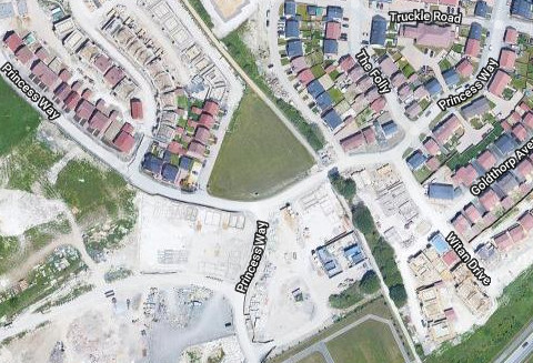
† The image below illustrates the “absence” of Muggleton Road. As mentioned in the body of the article, it appears to sit between southern and eastern arms of Princess Way. The siting of the place name sign (that appears in the image above) suggests that the road is located roughly in the area of the bend. And Muggle Road is not the name of the courtyard, which contains entrances for dwellings on Princess Way too. In the end, one can’t help begin to feel that there is no obvious point to “Muggleton Road”.
Further FBEL reading:
The Skripal incident: have Britain’s finest cocked up… again? (link)
Novichok… or fentanyl? No proof of a crime points to Skripal poisoning hoax (link)