


Some quietly stated surprises despite general Russian silence in Special Military Operation
The Russian Special Military Operation (SMO) in the Donbas is going through a “quiet” phase.
This is not due to loss of momentum, although this may be the impression given by open source intelligence (OSINT) aggregators and their social and alt media regurgitators, amongst whom there are some who have great reputations as stars of independent geopolitical analysis. This aspect of Russian operational hush is not the matter for this article, although it is a subject that deserves coverage, and therefore a piece dedicated to it is planned. Suffice it to say, at this time, that yet another opportunity is offered to see alternative media so-called expertise for the garbage it is, as a shortage of material makes it reach to retain audience.
But to stick to the point, despite how Russian forces generally appear to be working according to a policy of silence perhaps as strict as the one employed in the first days of their mission (so that some very silly people would claim that an armed conflict wasn’t happening) there is important news yet to be found that betrays how the SMO remains dynamically executed, rather than a static situation that a legion of stunningly bad “expertise” has aided enemy propagandists in presenting as being the state of affairs.
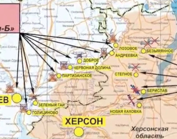
Amongst the maps below are ones taken from the Russian Ministry of Defence’s own presentation regarding developments in the SMO on 26th August. These are Figs. 1, 4 and 9, and they are the ones with the clear Ordnance Survey look about them.
Marked on these maps is shading (in red) which must represent what must be the Russian MoD’s own understanding about the positions of Russian forces in the south and east of the Ukraine.
The lines of contact between Russian and Ukrainian forces as indicated by this shading have been translated to copies of maps produced by liveuamap.com (Figs. 2, 3, 5, 6, 10 and 11) and the discrepancy between the two sources is shown in the blue shapes (with blue-line borders) added using a drawing tool which therefore show territory under Russian control in addition to what liveuamap.com (with its pro-Ukrainian bias) will admit to. In other words, the blue areas extend the range of Russian control beyond that recognised by the Ukrainian side, and as claimed by the Russians.
Also included below are two maps (Figs. 7 and 8) that show how liveuamap.com made a change on 22nd August presumable because the degree of a Russian advance between Kherson and Mykolaiv was such that it could not be denied. The two images together make an important set of graphics because what is illustrated is a shattering hammer blow to the current main plank of a major propaganda campaign to give a false appearance of Ukrainian capability to wage war. What is being proven in the images is that the Ukrainians cannot stage a counter offensive into Kherson, and in the wholly propaganda war being waged with UK sponsorship, it represents another sound thrashing in the same fashion of the one handed to the Ukrainians regarding Snake Island.
As bad as the Ukrainians have to admit things are towards Mykolaiv, the Russian reckoning claims an even tighter hemming in of the territory so that the physical city limits are only a handful of miles from Russian positions (see Fig. 11). A wise analyst would not predict what the Russians are going to do next, nor when they are going to do it, but only assume that they are positioning themselves in ways most conducive for whatever they intend.
Hinted at in the introduction to this piece was the concept that Russia was fighting in a flexible way that alternative and social media “expertise” just can’t get its head around – demonstrated at the moment with a fixation on the situation in the Donbas, and an expectation that it can only be resolved by a full frontal assault through settlements such as Soledar and Bakhmut. In the past, the same gross obtuseness was demonstrated by erroneously construing the end of the first chapter of the SMO, which had seen high mobility of Russian forces, as a reaction to Ukrainian success with anti-tank ambush (which was also wholly propaganda). In fact, the Russians just went to a new phase, and much so-called alternative and social media expertise apparently hadn’t heard of Russian artillery doctrine (and still hasn’t).
The point is that while the Donbas is all too obviously being used as a meat grinder towards the end of demilitarising Ukraine, the Russians can do more than this one thing at once. We’ve already looked at the more freely developing situation towards Mykolaiv, and if one looks at Figs. 1 and 2, one might be witnessing the beginning of the establishment of tighter control on three sides around Kharkov than there has previously been.
Moreover, if one collates together on one map what the Russian MoD suggests is the current situation in the Donbas (Fig. 6), there are signs that the Russians are working to move north and south along the borders of the territory of Donetsk, with the resultant encirclement being cut in two by a prong out of the environs of the Donetsk city itself. What is extremely significant about this information, of course, is that it suggests that the Russian lines have already advanced beyond the settlement of Avdiivka. This is entirely contrary to a running commentary provided by pro-Russian OSINT aggregators and regurgitators which holds that the Russians and Ukrainians are battling on the southern and eastern outskirts of the town.
The author, of course, has no problem with the idea that any state of affairs in the Donbas that the easy-to-discredit internet “expertise” would like to present has no actual relation to what is really happening. Indeed, if one looks at the Russian MoD map as it is shown in Fig. 12, the Russians would not appear to have penetrated as deeply – if at all – into the suburbs of Bakhmut (Artyomovsk – APTEMOBCK – is the Russian name) or Soledar (COЛEДAP) as the “expertise” maintains to be the case in another piece of running commentary that it provides. That the Russians aren’t actually trying to capture these towns might explain why they, against expectation, continually don’t. Perhaps what is really happening towards these places is action to pin Ukrainian forces while other attacks to uproot the enemy go in from other places (as the intelligence shown here possibly suggests). Indeed, a new claim being made today that Kodema (KOДEMA) has been captured is eminently plausible given the intelligence to be seen here (Fig. 4). This could be classified as being a gain in the intersecting prong around and out of Donetsk.
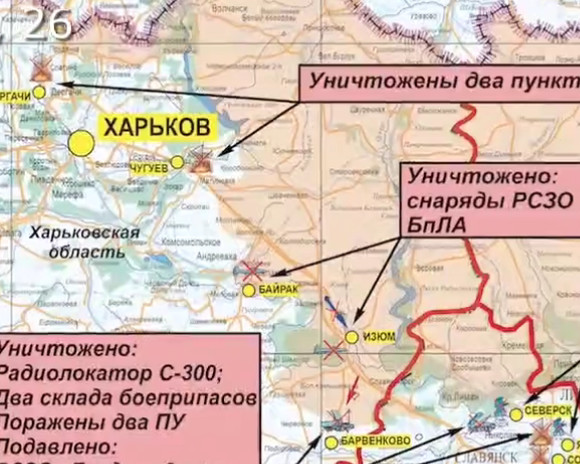
Fig. 1
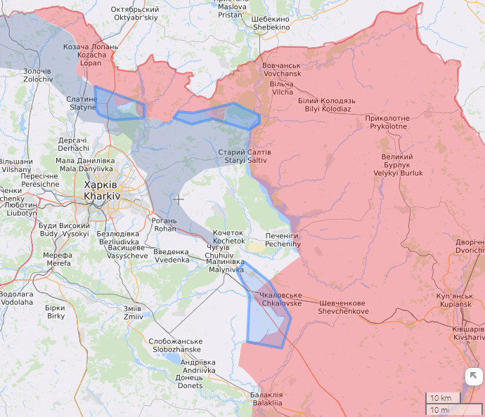
Fig. 2
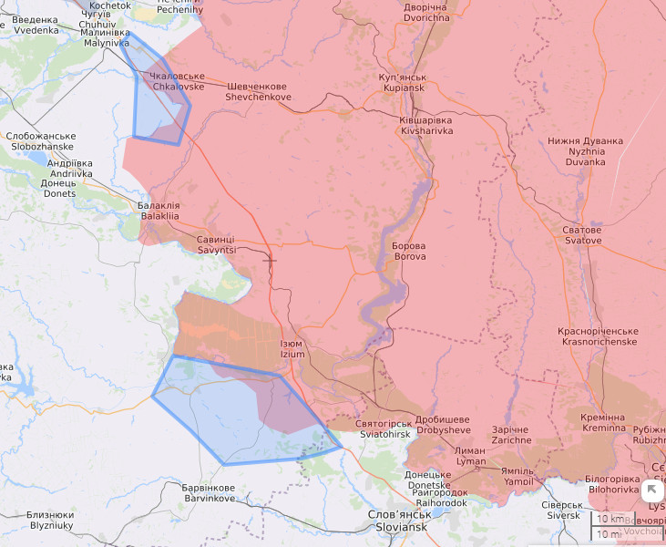
Fig. 3
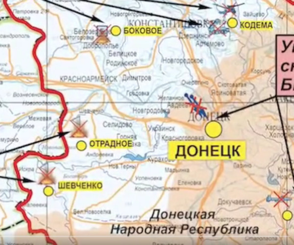
Fig. 4
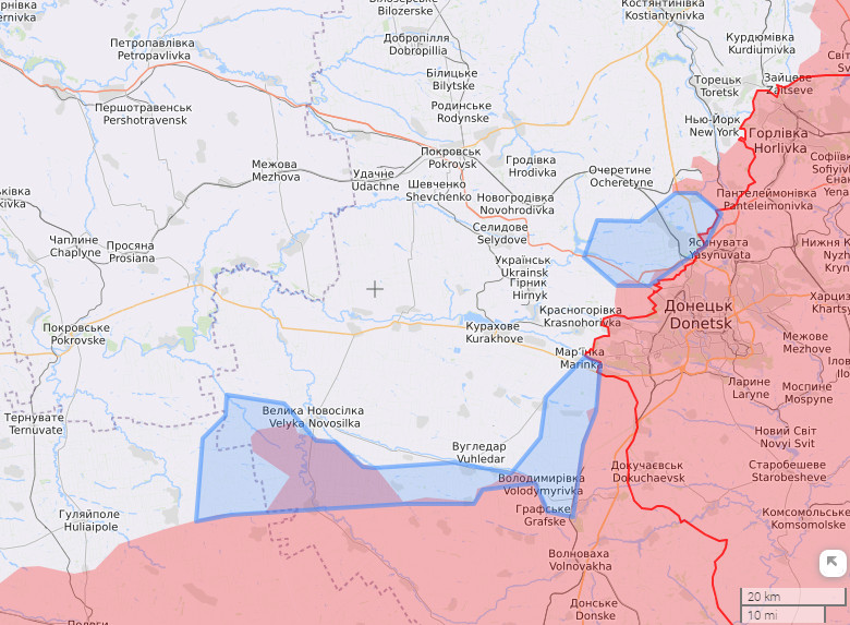
Fig. 5
Fig. 6
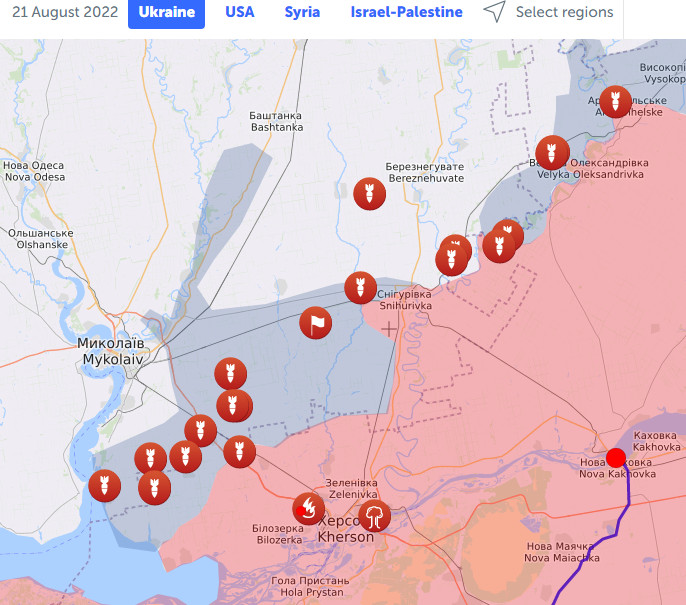
Fig. 7
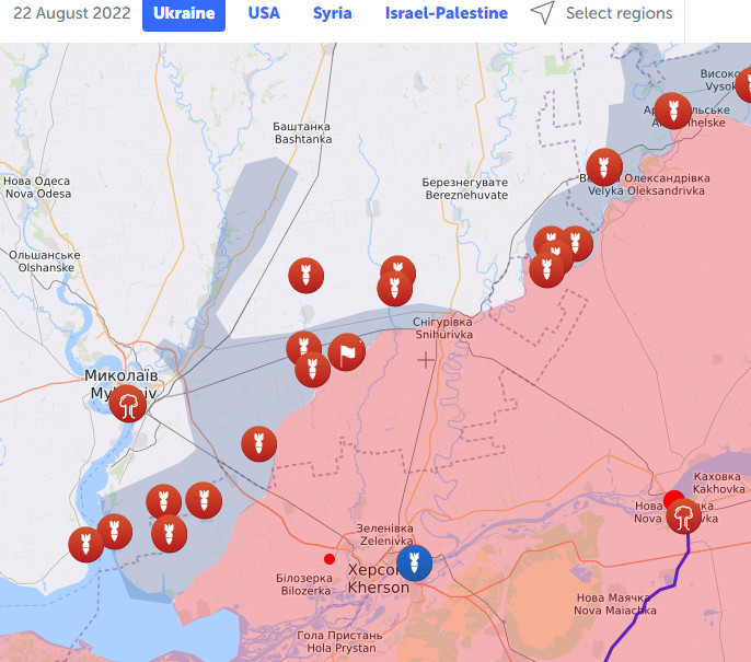
Fig. 8
Fig,. 9
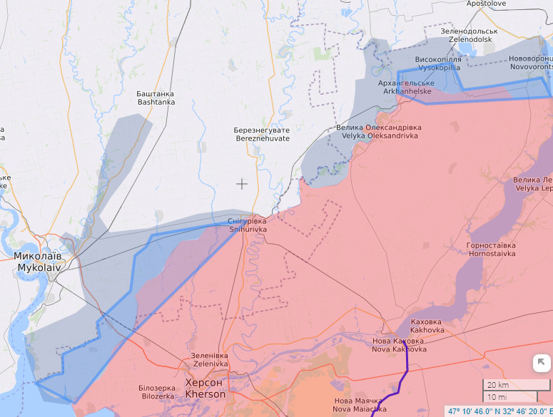
Fig. 10
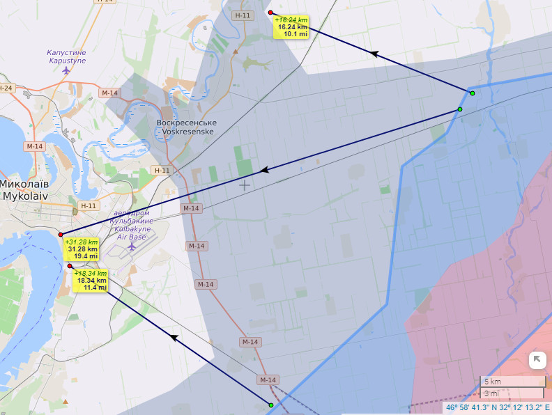
Fig. 11
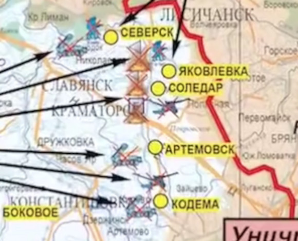
Fig. 12