


The Kupyansk and Krasny Liman directions
The reader will no doubt have heard in the past week that the Russians have liberated the settlements of Ozaryanovka, Kurdyumovka and Andreevka. Unless the author is mistaken, these three places run consecutively south to north on the west side of a railway that wends southward out of Artyomovsk (Bakhmut). The front line at this place, then, is about 4-mile westwards of the Bakhmutovka river, which itself was being contemplated at this site as a feature of future conquest for the Russians back in August. As one can see if one compares the map from that time (found here†) with the one embedded in the previous article on the subject (The Russian Winter Campaign Has Evidently Already Started (?)), if Russian progress has been steady, it has nevertheless been relentless. And the author is sure it will continue to be relentless – if not a little bit pacier for the reasons of Russian mobilisation and Ukrainian attrition. While some (meaning alternative media that is authoritative by dint of the great number of its following) are predicting an attack like a hammer falling and visiting many parts of Ukraine all at once, the author doesn’t think so, and believes that as we look at settlements the likes of Kurdyumovka being liberated one at a time, we are seeing the nature of Russia’s winter operation even as it has already started (with disclaimer as recorded in said previous article‡).
Speaking of Kurdyumovka, anyone who happened across this site from November 24th to 26th (when the above-mentioned article was being assembled as a published but unfinished piece) will have heard about the liberation of this town first:
The author is confident that the Russians are indicating that they have, in recent days, pushed the Ukrainians out of Lugansk but for a square mile or two here and there, have developed the area of their control north of Soledar, and taken control of the settlement shown on this Ukrainian convention base map (from liveuamap) as Kurdiumivka.
The tool by which the discernment was made – as alluded to in the extract – was a map presented with a Russian Ministry of Defence briefing for 24th November. This map itself was contrasted with one from 13th November, so it’s quite feasible that Kurdyumovka was taken at any point in the intervening time. The Russian Ministry of Defence declared the town officially “completely liberated” in the briefing of 2nd December. That the “pro-Russian” mongers of this sort of information on Telegram and Twitter only started to announce the taking of the town on 28th November supports the author’s belief that they don’t get real Russian intelligence fresh from the ground (but then, their entire value [for their masters] is in disseminating Ukrainian propaganda).
In any case, the glib reference in the above extract to the state of affairs in areas north of Donetsk (i.e., those square miles of Lugansk) is unfortunately characteristic of the coverage that this site has recently given to the theatres which the Russians call the Kupyanskand Krasny Liman directions. To rectify the matter, and because the Russian MoD maps are worth a hundred OSINT-mongers a week later, it was decided that some space must be made over to inspecting the situation on the Russian front line through Lugansk and Kharkov.
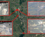
Checking the Ukrainian claims on the base map by liveuamap.com (dated 3oth November), shown below, against those of the Russian MoD (shown by the overlaid orange line extracted from a map accompanying the daily briefing of the same date), the Russians indicate their positions are more advanced along most of the line. The Russian bulge in Kharkov will surprise anyone who hasn’t been looking at the Russian maps regularly. This territory was never withdrawn from, although the Ukrainians claimed it was no longer under Russian control after their “offensive”. It wasn’t until the Russians withdrew from Kherson city that liveuamap admitted the Kharkov reality on the quiet, burying it under this other news.
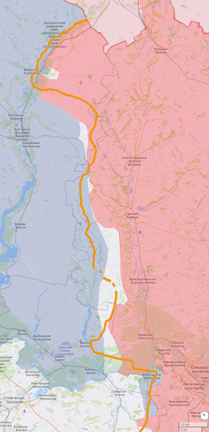
Click to enlarge.
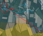
Now to look at the situation along the line more closely, the following maps are Google maps with the same orange line overlaid, and also a blue line to represent the Ukrainian reckoning. This line is unbroken where it falls inside the Russian area of control and is dotted where it falls outside of it. The purpose is to discover which settlements are a matter of controversy according to Russian and Ukrainian reckoning (i.e., the ones that fall between the full lines).
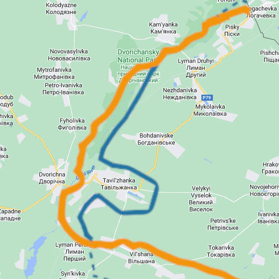
At the very north of the line is this unlikely situation according to the Ukrainians where the village of Tavolzhanka (Tavil’zhanka) sticks out in its entirety into a Russian encirclement. The Russian version, where it is captured, makes more sense.
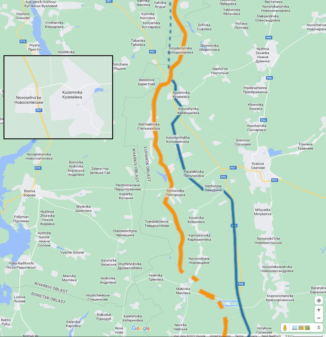
Click to enlarge
Further south, and Kuzemovka (Kuzemivka), Novosyolovskoye (Novolselivs’ke? – see inset), Stelmakhovka (Stel’makhivka) and Kotlyarovka (Kotlyarivka) were mentioned in the Russian MoD briefings on 30th November, and 1st and 2nd December. It was indicated that the first two settlements were being defended from Ukrainian attack, while Stelmakhovka came across as being of an indetermined status, with the Russians possibly encountering Ukrainians as they moved on the settlement. As for Kotlyarovka, the sense was very firmly of it being a place the Ukrainians were moving forward from. Needless to say, the Ukrainians suffered scores of casualties at these places (along with losing a number of tanks, armoured personnel carriers and infantry fighting vehicles – and the now usual civilian car [or two] – to boot) Incidentally, it shouldn’t be assumed that in such cases the Russians are always dealing with attacking forces. It could be that the Russians are simply frustrating Ukrainian attempts to reach forward defensive positions.
Click to enlarge.
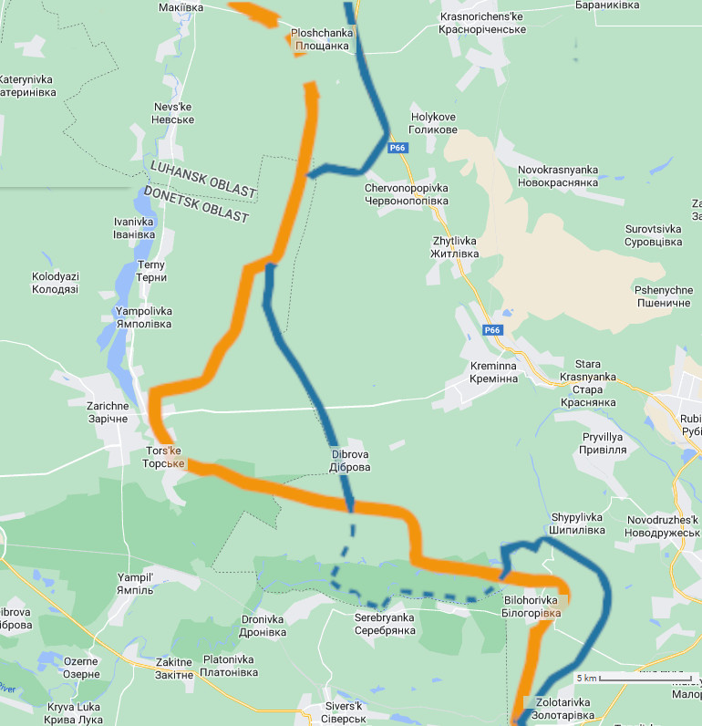
At the southernmost part of the line, and getting towards and into Donetsk, the Russians also very recently (30th November) reported deflecting the Ukrainians moving towards Ploshchanka (that the orange line is broken in this area indicates that the Russian map isn’t clear as to the exact situation, but the report appears to confirm the Russians hold it), Chervonopopovka (Chervonopopivka) and Zhytlovka (Zhytlivka). The Belogorovka (Bilohorivka) that is shown as being mostly surrounded by the Russians is most likely the same settlement as was announced as being fully liberated on 30th November (the Russian map was out of date already, or the line got misplaced in translation). [Correction, 7th December: there’s a duplicately named placed a few miles away to the south but in Donetsk (not Lugansk), northeast of Soledar, that this site has reckoned that Russia had already taken. Nevertheless, the Russians continue to develop their advance in this area, and the announcement represents acknowledgment of this].
† Excuse the use of the Rybar source material. The author didn’t know then what he knows now about its value.
‡ An argument for the Russian winter operation as more of the same is set out in said cited article, but also see The Russian Partial Mobilisation Is But A Component In What Was Always An Inevitability, an article from September, from whence the following is extracted:
Again, this is not about putting infantry boots on the ground; it’s not about literally closing off the space between the shoulders of ranks of soldiery. If one has managed to catch the story of State Duma Deputy Milonov, a politician who was called up, it has an unsurprising denouement if one knows how the Russian armed forces are calibrated to fight: Milonov has become an artilleryman.
What the Russians have done, we can suppose, is enlarge the forces dedicated to Ukraine according to current proportions in order to wage artillery doctrine warfare in more places at once, or in greater depth when required. There’s also a matter of forming standard defence structures as the ex-Ukrainian territories come into the jurisdiction of homeland military. It’s definitely not about sending “grunts”. And although the glitterati of the alternative media geopolitical analysis scene want their audience to understand what happened in Kharkov as a defeat for the Russians, the truth is that in this conflict Ukraine hasn’t been able to move in any meaningful way unless the Russians have allowed them to do it – and all with a fraction of the numbers now being made available. Hopefully, how the situation has just degenerated even further for the Ukrainians is something that is patently self-evident.
It’s quite possible that a problem that the big names of alternative media geopolitical analysis will be having is that they won’t (by order) or can’t (by ignorance) impart the most fundamental of necessary information to their audiences regarding Russia’s system of warfare, and so everyone must be given the idea that the Special Military Operation is like other conflicts, and especially those in which grand, all-encompassing gestures have to be made, and where their lacking can be taken as a declamatory statement on prowess, capability and prospects for success. The Ukrainian use of the Human Wave attack doctrine – which might have looked good for Western newspaper headlines but was an unmitigated disaster for the anti-Russian axis – has not helped in this respect either.
At some stage, and it is felt hereabouts that this juncture has arrived, Russia will exploit the demilitarisation that it has made Ukraine to suffer and advance to capture and occupy huge swathes of what is presently Ukrainian controlled territory. Naturally, there is Donetsk, Zaporozhe and Kherson to fully liberate, but there is also the denial of ground to Kiev to consider. Generally, this would mean making sure that Kiev cannot stage any forces it might muster to threaten Russian territory, or making sure that Kiev cannot produce to contribute to a war effort. Of course, the latter can be done with standoff weapons, but as it is quite feasible that NATO could send “Ukrainians” (i.e. other nationalities in Ukrainian uniform) from all over Europe, Britain (and Commonwealth) and North America into the future for a duration that one can only guess at (although the flow of heavy weaponry is something more coagulated altogether), one must suppose that Russia will have to physically block access to its Novorossiyan borders by occupying parts of Ukraine – and therefore at the same time in order to force a surrender. Now, this other territory is something that the Russians might invade with broad sweeps, but only at a time, the author would suggest, when the Ukrainian forces are for the most part expelled from the new Russian homeland, and have suffered such degradation in the process that the situation to Kiev’s US/UK masters will appear hopeless.
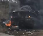
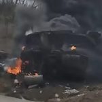
[The featured image purportedly shows part of a Ukrainian convoy as was destroyed “near Kreminna”]
Update, 4th December, 2022:
If the reader would like to consult the 2nd Google map, in the Russian Ministry of Defence briefing of this date, there was this: “An attempt to attack Russian military positions near Yagodnoye (Kharkov region), has been thwarted as a result of a fire attack on a concentration of AFU manpower and military equipment near Kislovka.” It suggests that the Russians may have advanced in direction of the line formed by Ivanivka-Kyslivika-Kotlyarivka (to use the spellings as the map does).
And in respect of the 3rd Google map, this day’s Russian MoD briefing also had this: “The attack by two attack groups of the AFU towards Kremennaya (Lugansk People’s Republic) has been disrupted by a fire strike near Serebryanskoye lesnichestvo and decisive actions of the Russian troops.” In the map one can see that to the south and west of Kremennaya there are forested areas in Donestk and Lugansk on the Ukrainian side of the line. The latest Russian map appears to show the Russian front cut across the forest in Donetsk from Tors’ke to the counterpart in Lugansk, and continue parallel to its basic orientation (west to east) within the boundary of the forest itself. The information could be suggesting an advance towards Serebryanka [additional, 12th December: in fact, a proper check reveals no map change, see Charted: Russian Activity In The Kupyansk And Krasny Liman Directions In December Thus Far].
Update, 5th December, 2022:
In support of the supposition made in the first paragraph of the previous update, this is from the Russian MoD’s briefing of this date:
In Kupyansk direction, a company tactical group of the Armed Forces of Ukraine (AFU) near Tabayevka (Kharkov region) has been hit by gunfire. In total, 65 Ukrainian servicemen were neutralised, as well as two infantry fighting vehicles, and two pickup trucks.
Although there are other possibilities, gunfire strongly suggests engagement between ground forces.