


Keep watching southern Donetsk
It would very much appear that the section of the frontline that is least active at this time in the Russian undertaking known as the Special Military Operation is that which incorporates Southern Donetsk and Zaporozhe. This is in terms of Russian offensive action, to be entirely clear. And just to press the point to the reader who may have a misapprehension caused by reports by the mongers of OSINT on Twitter and Telegram, the Russian Ministry of Defence in its briefings now only uses the word “offensive” to describe attacks by its own forces on Ukrainian “military manpower and (its) equipment”, to offer a paraphrasing (the word “troops” will be used here for shorthand). True, in recent weeks the Russians may well have started mentioning the destruction of Ukrainian “sabotage and reconnaissance” units presumably discovered within Russian areas of control, but for all intents and purposes, there are no Ukrainian “offensives”.
Fig. 1. Information from Russian MoD briefings of 22nd to 31st December. Orange: attacks on Ukrainian troops; Blue: on artillery emplacements and related; Purple: on command posts and ammo depots.
Of course, the matter of which section of front line is least active is a close run thing, and anyone looking at the map in Figures 1 and 2 might wonder why such a title has been awarded the very busy looking line(s) shown there. However, when the gauge is the placement of Russian attacks on Ukrainian troops so as to possibly suggest forward movement, arguably there’s greater progress to be measured in the Donetsk, Krasny Liman and Kupyansk directions.
Let’s deal with these others first.
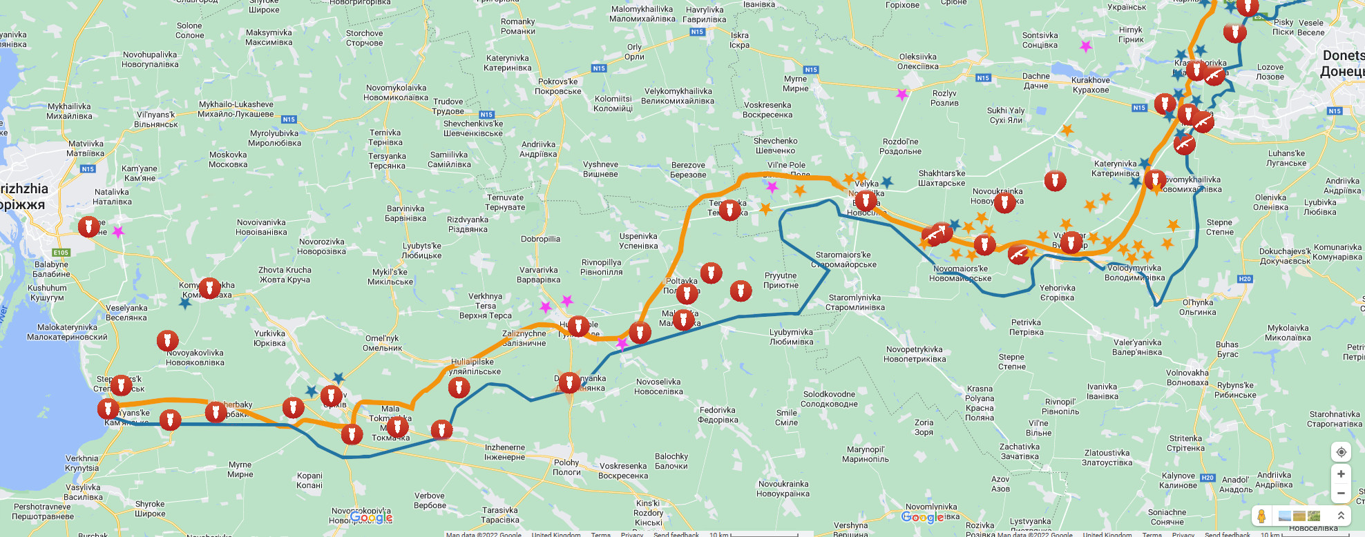
Fig. 2. As Figure 2, but with information from the pro-Ukrainian liveuamap overlaid.
There’s been a tendency hereabouts to treat the Kupyansk and Krasny Liman directions together, and so this will be how it goes on. The map in Figure 4 shows an account of this theatre of the conflict and the Russian front line as reckoned from Russian MoD maps – unchanged, it should be noted, since the last time it was looked at (in the article Charted: Russian Activity In The Kupyansk And Krasny Liman Directions In December Thus Far). In fact, if the reader will consult the map produced at that previous time then developments at this sector become evident by the contrast.
Firstly it should be noted how the Russians are hitting targets beyond their front line (almost exclusively) according to an interpretation of the Russian MoD reports – and a word must be had about this. The briefings always go along the same lines where Ukrainian troops are hit in their forward movements, or – as is the case practically universally now – where they are found in defensive positions or in staging concentrations, are said to have been attacked and suffered casualties “near” a particular settlement. The preciseness of this quality of being “near” a place is an unknown quantity. On maps produced for this site, the attack is indicated loosely as close as possible to the settlement named. In the one of our current interest (Fig. 4), the only time anything approaching licence has been applied is when the attacks near Dibrova are placed on the Ukrainian side of the line.
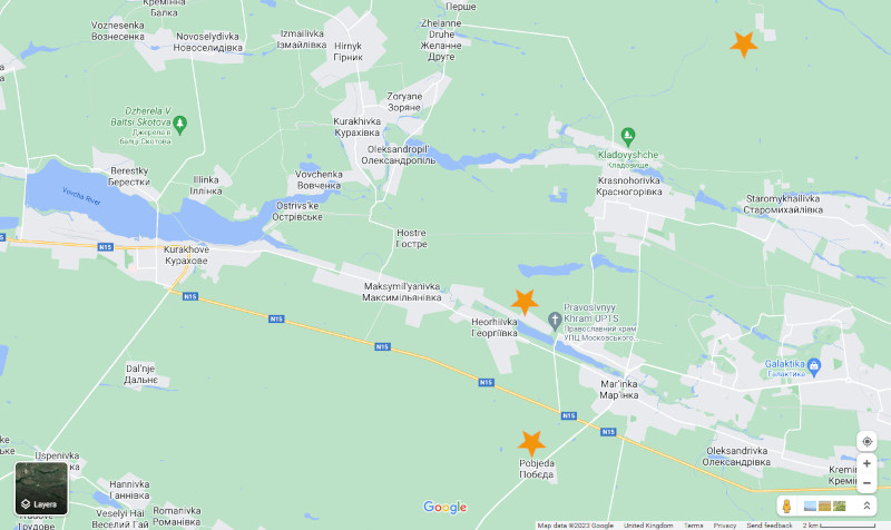
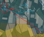
Fig. 3. 3rd January, attacks on Ukrainian troops around Maryinka, as reported by Russian MoD.
What is suggests in the pattern is the pressing back of Ukrainian forces – whether or not the Russians are in immediate contact and applying the pressure isn’t determinable in some reports, possible by an interpretation in others, and then also in some cases clearly not the factor involved when stand-off weapon attack is explicitly stated. That being said, the aspect of the information on the map that is most interesting is where the Ukrainians are pressed in a line from Stelmakhovka to Makeyevka to Torskoye. Contrast with the previous data which showed Russians dealing with Ukrainian “counter attacks” within the Russian area of control all along the line in the Krasny Liman direction. In Kupyansk, the data arguably shows that Kuzemovka has been relieved, and more clearly that Russian targeting encroaches ever closer to Kupyansk itself from the north – whatever that actually represents. All in all, the attacks are going in at much the same places, so it’s a sector that is to be watched closely for further spectacular development because it’s a sector that is closely and crucially connected to a propagandised image of Ukraine as a war-capable entity.
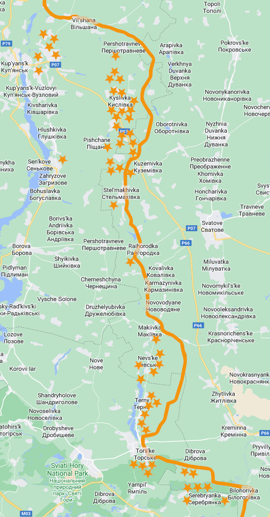
Fig. 4. In the Kupyansk and Krasny Liman directions, attacks on Ukrainian troops, 22nd December to 2nd January.
What the Russians are doing to the south of Krasny Liman is currently always presented in an overtly different way, as the reader can see from the following quotation taken from a typical briefing:
In Donetsk direction, Russian forces continued their offensive operations that have resulted in taking new advantageous lines and positions.
The language is unambiguous and indicates an intent to engage directly and remove Ukrainians from their defensive positions. Not unexpectedly, perhaps, the Russian MoD is consequently sometimes not forthcoming with exact details, and so in some reports coming out at this time the Ukrainian casualties will be given, but not the locations where they occurred. There is enough information, however, to get a good gist of what is happening, and Russian activity certainly does look like it is unseating Ukrainians. FBEL reported on this direction quite recently in the article Artyomovsk And Soledar, and so that there’s no unnecessary duplication of work, the reader must proceed to that page for further briefing.
Moving to the south, the information suggests that the Russians have dug the Ukrainians out from any reach they might have had as far as Slavnoye and Stepnoye in the “corner” of this front. The map in Figure 1 also shows the blue line of Ukrainian reckoning for the edge of Russian control, and the last time that this scene was looked at (in the article Watch Southern Donetsk), Russian attacks on Ukrainians between the two lines as deep as Slavnoye and Stepnoye was noted. In the latest report, this phenomenon is contained within a triangle formed by the settlements of Novomikhaylovka, Sladkoye and Vladimirovka, and it should be noted that a few of the incidents marked in this zone on the map were attacks on Ukrainian sabotage and reconnaissance units.
The interest for the Ukrainians is possibly the railway that continues from Donetsk city into Zaporozhe and also on another branch to Mariupol and runs very close to this zone, but under Russian control (of course). Speaking of Mariupol, at this Novomikhaylovka-Sladkoye-Vladimirovka triangle is where the Ukrainians are closest to that city, and of course it must be increasingly difficult to make proclamations of its re-conquest in 2023 when the Russians are quite obviously consolidating control in the avenue approaching it.
What is incredibly interesting is how the Ukrainians never claim Russian activity in this “corner” – Figure 2 is a good example (where some illustrative icons selectively taken from the reporting for the same time period at liveuamap.com have been overlaid in the same positions). The denial of any threat, let alone loss of complete control of the zone, must be to do with the maintenance of the propagandised image of Ukraine as war-capable, which is partly constituted by the fantasy of recapturing Mariupol.
As with its northern counterpart, the Russians use the word “offensive” in relation to their doings in Southern Donetsk – but not nearly so frequently. The maps (Figures 1 and 2) overwhelmingly tend to suggest that the Russians are trying to gain the road perhaps from Velikaya Novosyolka to Vladimirovka in the first instance. In that context, the announced liberation of Dorozhnyanka (indicated by a large transparent orange star) comes out of the blue. It could be one of those times when official Russian announcements about this sort of thing catches up with map-work. The OSINT-mongery chatter has it that the Russians are looking to take Gulyaipole situated to the north of the scene of the “latest” liberation. However, Russian reporting does not indicate any attacks on Ukrainian troop groupings all along the line as it exists in Zaporozhe – interesting given how the Ukrainians show it frequently being shelled.
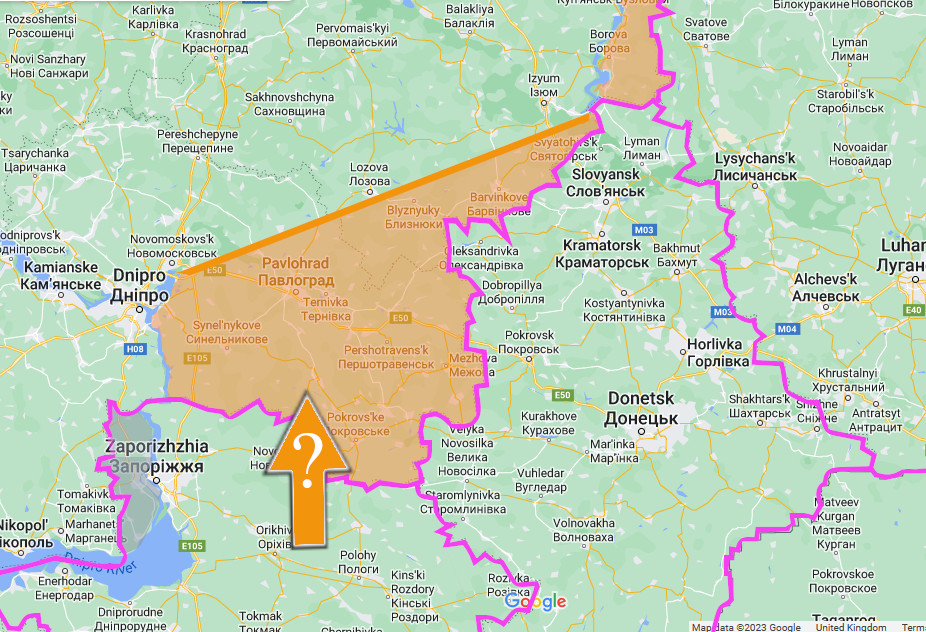
Fig. 5. At last, a Zaporozhe offensive? The Russians doing to the Ukrainians what was meant to be done unto them?
It is written somewhere on the internet (the author has noticed) that if Russian armed forces personnel are going to be killed or otherwise made a casualty during their participation in the Special Military Operation, then it will most likely be due to an encounter with a landmine. (It certainly won’t be by freak HIMARS strike on a New Year’s gathering in a village hall [or whatever was the case in Makeyevka when tens of Russians were killed all at once] – and by the way, if careless use of mobile phones is found to be responsible, blame the culture of OSINT-mongery. In fact, as a matter of course blame as facilitators the OSINT-mongery that immediately looked to criticise an entire control structure, or inflate casualty numbers, when not having the first clue about the real facts in the case).
Could it be that the Russians are working to deal with discreet Ukrainian defences in the fields of Zaporozhe? What if there is very little Ukrainian army here (so much for that offensive, Brian/Tony/Maureen)? All remains to be seen, of course, but when one understands that the Russians must intend to capture all of the oblast, and when one notices that the road network is much better across the front line in Zaporozhe than it is when it traverses from Russian liberated Donetsk (and that it mostly heads in the right direction – north), it is reasonable to expect a new front to be opened here that could even be designed to overtake progress in the “corner” to the east, and box in that part of Donetsk which is not currently liberated. It would be like forming the other end of a sack to catch the most desirable territory – to match a counterpart on the opposite wing where the author would expect the Russians to advance to the Oskil River.
If the Russians also then proceed to Dnipro (see Figure 5), an effective front line of very short dimension – 120 mile – can be formed between two natural river barriers over which the Ukrainians could not operate, and which would contain the virtually completely liberated Zaporozhe, and the entirely liberated Donetsk and Lugansk. At that stage, it would be obvious that the Russians could not be budged and that the Ukrainians must surrender (on terms that will complete Zaporozhe, Kherson and even concede Odessa) or face further dismemberment in the next instalment. It is a scheme that certainly would be in keeping with the way that the Russians have waged limited war in Ukraine.
This is, of course, a very rare attempt at speculation regarding Russian options and actions because it is well understood at FBEL that such things aren’t known to anyone but Russian planners, and that attempting to make predictions is futile. The main point of the exercise, if it must be supposed, is to emphasise the Ukrainian situation, because an attack through Zaporozhe to the coast was a thing that couldn’t be done in 2022 when it was meant to have been, for the simple reason that the “million man” Human Wave had already been dashed to pieces. It is this section of front more than any other than represents the coming Ukrainian defeat, even if it is – at the moment – the quietest.